82nd Ave Transit Project logo

82nd Ave Transit Project

15% Design Proposal

The 82nd Avenue Transit Project has identified potential locations for station platforms. Here’s what the proposed station locations could look like.


The feedback period is now closed.

Proposed Station Locations

From 2022–24, the 82nd Avenue Transit Project identified general locations for station pairs. Considerations included important destinations, places where people transfer between transit lines, proximity to safe crossings and areas with high transit ridership. Now, the project is proposing more specific locations for each station platform, where buses can serve riders quickly and avoid being stuck in traffic. Usually, this is past an intersection.

Section 1:
NE Cully Blvd to 82nd Ave

  1. NE Killingsworth St, NE Cully Blvd and NE Lombard St

    Map showing where the 82nd Ave FX Line runs in a triangular loop from NE Lombard St to NE Cully Blvd and NE Killingsworth St. There are existing traffic signals where NE Cully Blvd intersects NE Lombard St and NE Killingsworth St. There is an FX station and a Line 72 stop closing at the corner of Cully & Killingsworth. There is a future Line 72 stop on NE Cully Blvd between Killingsworth & Lombard. Line 72 and planned Line 29 run parallel to the 82nd Ave FX line and then continue west on NE Killingsworth St. Planned Line 71 runs parallel to the 82nd Ave FX line and then continues southwest on NE Cully Blvd. The following businesses are included on the map: Community Transitional School, Hacienda CDC, and Las Adelitas.

    Map key

    light green line
    82nd Ave FX Line
    bright green rectangle
    FX station
    white circle with a black outline
    Future Line 72 stop
    white circle with a black outline and a light gray X covering the circle
    Line 72 stop closing
    light blue solid line
    Existing TriMet bus line
    light blue dashed line
    Future planned bus line
    white traffic light icon on a dark gray circle
    Existing traffic signal
  2. NE Lombard St and 72nd Ave

    Map showing where the 82nd Ave FX Line runs on NE Lombard St, intersecting NE 72nd and NE 73rd Ave. There is one existing traffic signal at the intersection on NE 72nd Ave, and two FX Station Platforms. Line 72 runs parallel to the SE 82nd Ave line, along with planned Lines 49 and 71. Plaid Pantry is highlighted on the map.

    Map key

    light green line
    82nd Ave FX Line
    light blue solid line
    Existing TriMet bus line
    light blue dashed line
    Future planned bus line
    white traffic light icon on a dark gray circle
    Existing traffic signal
  3. NE Lombard St and 75th Ave

    Map showing where the 82nd Ave FX Line runs on NE Lombard St, intersecting NE 75th Ave. A future Line 72 stop is marked on the westbound side of the intersection. Line 72 runs parallel to the SE 82nd Ave line, along with planned Lines 49 and 71. Gartner's Country Meat Market is highlighted on the map.

    Map key

    light green line
    82nd Ave FX Line
    light blue solid line
    Existing TriMet bus line
    light blue dashed line
    Future planned bus line
    white circle with a black outline
    Future Line 72 stop
  4. NE Lombard St 7600 Block

    Map showing where the 82nd Ave FX line runs on the 7600 block of NE Lombard St. A future Line 72 stop is marked on the eastbound side. Line 72 runs parallel to the SE 82nd Ave line, along with planned Lines 49 and 71.

    Map key

    light green line
    82nd Ave FX Line
    light blue solid line
    Existing TriMet bus line
    light blue dashed line
    Future planned bus line
    white circle with a black outline
    Future Line 72 stop
  5. NE Lombard St and 82nd Ave

    Map showing where the 82nd Ave FX Line turns from NE Lombard St onto NE 82nd Ave. There is an existing traffic signal at the intersection. Line 72 and planned Line 49 run parallel to the 82nd Ave line, with planned Line 71 continuing on NE Lombard St.

    Map key

    light green line
    82nd Ave FX Line
    light blue solid line
    Existing TriMet bus line
    light blue dashed line
    Future planned bus line
    white traffic light icon on a dark gray circle
    Existing traffic signal


Section 2:
NE Lombard St to I-84

  1. NE Lombard St

    Map showing where the 82nd Ave FX Line continues from NE Lombard St onto NE 82nd Ave. There is an existing traffic signal at the intersection. Line 72 and planned Line 49 run parallel to the 82nd Ave line. The following businesses are highlighted on the map: Modern Machinery Co and United Rentals.

    Map key

    light green line
    82nd Ave FX Line
    light blue solid line
    Existing TriMet bus line
    light blue dashed line
    Future planned bus line
    white traffic light icon on a dark gray circle
    Existing traffic signal
  2. NE Alberta St

    Map showing where the 82nd Ave FX Line runs on NE 82nd Ave, intersecting OR 213, NE Webster St, NE Alberta St, and NE Humboldt St. There is an existing traffic signal at the intersection of OR 213. The intersection at NE Alberta St has a planned traffic signal, two FX station platforms, a Line 72 stop closing and a crosswalk closing. Line 72 and planned Line 49 run parallel to the 82nd Ave line. The following businesses are highlighted on the map: Stand's Food & Deli, Howliday Inn Doggie Hotel, and Studio 6.

    Map key

    light green line
    82nd Ave FX Line
    bright green rectangle
    FX station
    white circle with a black outline and a light gray X covering the circle
    Line 72 stop closing
    light blue solid line
    Existing TriMet bus line
    light blue dashed line
    Future planned bus line
    white traffic light icon on a dark gray circle
    Existing traffic signal
    white traffic light icon on a bright pink circle
    Planned traffic signal
    white pedestrian icon on a dark gray diamond and a light gray X covering the circle
    Crosswalk closing
  3. NE Wygant St to NE Going St

    Map showing where the 82nd Ave FX Line runs on NE 82nd Ave, intersecting NE Wygant St, NE Going St, and NE Going Pl. There are two Line 72 stop closings, one at each side of the NE Wygant intersection. Line 72 and planned Line 49 run parallel to the 82nd Ave line.

    Map key

    light green line
    82nd Ave FX Line
    white circle with a black outline and a light gray X covering the circle
    Line 72 stop closing
    light blue solid line
    Existing TriMet bus line
    light blue dashed line
    Future planned bus line
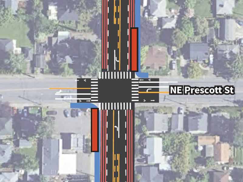
  4. NE Prescott St

    Map showing where the 82nd Ave FX Line runs on NE 82nd Ave, intersecting NE Prescott St and NE Skidmore St. There is an existing traffic signal at the intersection of NE Prescott St, two FX station platforms, a Line 72 stop closing on either side, and a planned Line 72 stop on the eastbound side of NE Prescott St. Line 72 and planned Line 49 run parallel to the 82nd Ave line until turning east at NE Prescott St. Line 71 runs perpendicular to the 82nd Ave FX Line at NE Prescott St. The following businesses are highlighted on the map: Global Friends Language School and Portland Tire Shop #1.

    Map key

    light green line
    82nd Ave FX Line
    bright green rectangle
    FX station
    white circle with a black outline and a light gray X covering the circle
    Line 72 stop closing
    white circle with a black outline
    Future Line 72 stop
    light blue solid line
    Existing TriMet bus line
    light blue dashed line
    Future planned bus line
    white traffic light icon on a dark gray circle
    Existing traffic signal
  5. NE Sandy Blvd

    Map showing where the 82nd Ave FX Line runs on NE 82nd Ave, intersecting NE Sandy Blvd. There is an existing traffic signal at the intersection, two FX station platforms, and a Line 72 stop closing on either side. Line 12 runs on NE Sandy Blvd. Planned Line 24 runs parallel to Line 12 until NE 82nd Ave, where it turns south on NE 82nd Ave. The following businesses are highlighted on the map: Quality Inn Portland Airport PDX, 7-Eleven, Cameo Motel, Green Front Dispensary Sandy, and The Heights at Columbia Knoll.

    Map key

    light green line
    82nd Ave FX Line
    bright green rectangle
    FX station
    white circle with a black outline and a light gray X covering the circle
    Line 72 stop closing
    light blue solid line
    Existing TriMet bus line
    light blue dashed line
    Future planned bus line
    white traffic light icon on a dark gray circle
    Existing traffic signal
  6. NE Failing to NE Beech

    Map showing where the 82nd Ave FX Line runs on NE 82nd Ave, intersecting NE Failing St and NE Beech St. There is an existing pedestrian crossing signal at the NE Beech St intersection, along with a Line 72 stop closing on either side. Planned Line 24 runs parallel to the 82nd Ave FX Line. The following businesses are highlighted on the map: Evergreen Inn & Suites Portland Airport, Moda Handyman, Salt & Pepper Peruvian Food Cart 82 Ave, and Madison Suites.

    Map key

    light green line
    82nd Ave FX Line
    white circle with a black outline and a light gray X covering the circle
    Line 72 stop closing
    light blue dashed line
    Future planned bus line
    white pedestrian icon on a dark gray diamond
    Existing pedestrian crossing signal - flashing beacon
  7. NE Fremont St

    Map showing where the 82nd Ave FX Line runs on NE 82nd Ave, intersecting NE Milton St and NE Fremont St. There is an existing traffic signal at the NE Fremont St intersection, along with FX station platforms on either side. Planned Line 24 runs parallel to the 82nd Ave FX Line until NE Fremont St, where it meets existing Line 24. The following businesses are highlighted on the map: Domino's Pizza, First Orthodox Presbyterian Church, Popeyes, Mainspring Portland, Plaid Pantry, 76, Shell, and Portland Veterinary Wellness Center.

    Map key

    light green line
    82nd Ave FX Line
    bright green rectangle
    FX station
    light blue solid line
    Existing TriMet bus line
    light blue dashed line
    Future planned bus line
    white traffic light icon on a dark gray circle
    Existing traffic signal
  8. NE Klickitat St

    Map showing where the 82nd Ave FX Line runs on NE 82nd Ave, intersecting NE Klickitat St. There is an existing traffic signal and a Line 72 stop closing on either side of the intersection. The following businesses are highlighted on the map: McDonald's, Bag O' Crab, and Madison Heights Plaza.

    Map key

    light green line
    82nd Ave FX Line
    white circle with a black outline and a light gray X covering the circle
    Line 72 stop closing
    white traffic light icon on a dark gray circle
    Existing traffic signal
  9. NE Siskiyou St

    Map showing where the 82nd Ave FX Line runs on NE 82nd Ave, intersecting NE Siskiyou St. There is an existing traffic signal and a Line 72 stop closing on either side of the intersection. The following are highlighted on the map: El Burrito Loco #3, Subway, Mekong Bistro, and Glenhaven Park.

    Map key

    light green line
    82nd Ave FX Line
    white circle with a black outline and a light gray X covering the circle
    Line 72 stop closing
    white traffic light icon on a dark gray circle
    Existing traffic signal
  10. McDaniel High School

    Map showing where the 82nd Ave FX Line continues on NE 82nd Ave south of NE Siskiyou St. There is an existing traffic signal and two FX station platforms by the entrance to McDaniel High School. Great Floors and McDaniel High School are highlighted on the map.

    Map key

    light green line
    82nd Ave FX Line
    bright green rectangle
    FX station
    white traffic light icon on a dark gray circle
    Existing traffic signal
  11. NE Russell St

    Map showing where the 82nd Ave FX Line runs on NE 82nd Ave, intersecting NE Russel St and NE Brazee St. There is an existing pedestrian crossing signal at the NE Russell St intersection. The following businesses are highlighted on the map: The People's Courts, States Motel, Pho Oregon Restaurant, and RPM Automotive.

    Map key

    light green line
    82nd Ave FX Line
    white pedestrian icon on a dark gray diamond
    Existing pedestrian crossing signal - flashing beacon
  12. NE Thompson St

    Map showing where the 82nd Ave FX Line runs on NE 82nd Ave, intersecting NE Sacramento St, NE Thompson St and NE Eugene St. There is an existing pedestrian crossing signal at the NE Thompson St intersection, as well as a Line 72 stop closing on each side. The following businesses are highlighted on the map: VIP Performance, Taco Bell, Bolero Club, and New Happy Fortune Chinese Restaurant.

    Map key

    light green line
    82nd Ave FX Line
    white circle with a black outline and a light gray X covering the circle
    Line 72 stop closing
    white pedestrian icon on a dark gray diamond
    Existing pedestrian crossing signal - flashing beacon
  13. NE Tillamook St

    Map showing where the 82nd Ave FX Line runs on NE 82nd Ave, intersecting NE Tillamook St and NE Hancock St. There is an existing traffic signal at the NE Tillamook St intersection, as well as two FX station platforms. The following businesses are highlighted on the map: Plaid Pantry, Portland Closeout, Les Schwab Tire Center, and University of Western States.

    Map key

    light green line
    82nd Ave FX Line
    bright green rectangle
    FX station
    white traffic light icon on a dark gray circle
    Existing traffic signal
  14. NE Schuyler St

    Map showing where the 82nd Ave FX Line runs on NE 82nd Ave, intersecting NE Schuyler St and NE Broadway St. There is an existing traffic signal at the NE Schuyler St intersection, as well as Line 72 stop closings on either side. The following businesses are highlighted on the map: Banfield Pet Hospital, Portland Animal Welfare Team, and Portland Value Inn.

    Map key

    light green line
    82nd Ave FX Line
    white circle with a black outline and a light gray X covering the circle
    Line 72 stop closing
    white traffic light icon on a dark gray circle
    Existing traffic signal
  15. I-84

    Map showing where the 82nd Ave FX Line runs on NE 82nd Ave, intersecting NE Halsey St, NE Jonesmore St, and I-84. There is an existing traffic signal at the NE Jonesmore St intersection, as well as two FX station platforms and a MAX station. The Cypress Inn is highlighted on the map.

    Map key

    light green line
    82nd Ave FX Line
    bright green rectangle
    FX station
    white train icon on a dark gray circle
    MAX station
    light blue solid line
    Existing TriMet bus line
    white traffic light icon on a dark gray circle
    Existing traffic signal


Section 3:
I-84 to SE Mill St

  1. NE Wasco St

    Map showing where the 82nd Ave FX Line runs on NE 82nd Ave, intersecting I-84 and NE Wasco St. There is an existing traffic signal at the NE Wasco St intersection. Line 77 runs parallel to the 82nd Ave FX Line until turning west on NE Wasco St. Eastern Cathay is highlighted on the map.

    Map key

    light green line
    82nd Ave FX Line
    light blue solid line
    Existing TriMet bus line
    white traffic light icon on a dark gray circle
    Existing traffic signal
  2. NE Multnomah St to NE Hassalo St

    Map showing where the 82nd Ave FX Line runs on NE 82nd Ave, intersecting NE Multnomah St and NE Hassalo St. There is an existing traffic signal at the NE Multnomah St intersection. There are Line 72 stop closings at both interesections, northbound at NE Multnomah and southbound at NE Hassalo. The following businesses are highlighted on the map: Pappy's, Utopia Restaurant & Lounge, and Love Health Spa.

    Map key

    light green line
    82nd Ave FX Line
    white circle with a black outline and a light gray X covering the circle
    Line 72 stop closing
    white traffic light icon on a dark gray circle
    Existing traffic signal
  3. NE Holladay St to NE Pacific St

    Map showing where the 82nd Ave FX Line runs on NE 82nd Ave, intersecting NE Holladay St and NE Pacific St. There is a planned traffic signal and two FX stations at the NE Holladay St intersection. There is an exsiting pedestrian crossing signal at the NE Pacific St intersection. There is a Line 72 stop closing between the two intersections on the northbound side. The following businesses are highlighted on the map: Don Pedro Mexican Food #8, Chronix Dispensary, and Willamette Valley Color, LLC.

    Map key

    light green line
    82nd Ave FX Line
    bright green rectangle
    FX station
    white circle with a black outline and a light gray X covering the circle
    Line 72 stop closing
    white traffic light icon on a bright pink circle
    Planned traffic signal
    white pedestrian icon on a dark gray diamond
    Existing pedestrian crossing signal - flashing beacon
  4. NE Oregon St

    Map showing where the 82nd Ave FX Line runs on NE 82nd Ave, intersecting NE Oregon St. There is a line 72 stop closing on each side. The following businesses are highlighted on the map: Milepost 5 and Happy Dragon Chinese Restaurant.

    Map key

    light green line
    82nd Ave FX Line
    white circle with a black outline and a light gray X covering the circle
    Line 72 stop closing
  5. NE Glisan St

    Map showing where the 82nd Ave FX Line runs on NE 82nd Ave, intersecting NE Glisan St. There is an existing traffic signal and two FX stations at the intersection. Line 19 runs perpendicular to the 82nd Ave FX Line on NE Glisan St. The following businesses are highlighted on the map: Jacksons Food Stores, Montavilla Community Center, Shell, Burgerville, and Washman Car Wash Montavilla.

    Map key

    light green line
    82nd Ave FX Line
    bright green rectangle
    FX station
    light blue solid line
    Existing TriMet bus line
    white traffic light icon on a dark gray circle
    Existing traffic signal
  6. NE Davis St

    Map showing where the 82nd Ave FX Line runs on NE 82nd Ave, intersecting NE Everett St and NE Davis St. There is an existing traffic signal at the NE Davis St intersection as well as two Line 72 stop closings, one on each side. The following are highlighted on the map: Wendy's, Vestal Elementary School, Ace Tire and Wheel.

    Map key

    light green line
    82nd Ave FX Line
    white circle with a black outline and a light gray X covering the circle
    Line 72 stop closing
    white traffic light icon on a dark gray circle
    Existing traffic signal
  7. E Burnside St

    Map showing where the 82nd Ave FX Line runs on NE 82nd Ave, intersecting NE Couch St and E Burnside St. There is an existing traffic signal, two FX stations, and two Line 72 stop closings at the E Burnside St intersection. Line 20 runs perpendicular to the 82nd Ave FX Line on NE Burnside St. The following businesses are highlighted on the map: Walgreens, Cars To Go, Chevron, and Fortune BBQ Noodle House.

    Map key

    light green line
    82nd Ave FX Line
    bright green rectangle
    FX station
    light blue solid line
    Existing TriMet bus line
    white circle with a black outline and a light gray X covering the circle
    Line 72 stop closing
    white traffic light icon on a dark gray circle
    Existing traffic signal
  8. SE Ash St

    Map showing where the 82nd Ave FX Line runs on SE 82nd Ave, intersecting SE Ash St and SE Pine St. There is an existing pedestrian crossing signal and two Line 72 stop closings at the SE Ash St intersection. The following businesses are highlighted on the map: Hong Phat Food Center, Daisy Nail Supply, Tony's Auto World, and PDX Saints Love Day Shelter.

    Map key

    light green line
    82nd Ave FX Line
    white circle with a black outline and a light gray X covering the circle
    Line 72 stop closing
    white pedestrian icon on a dark gray diamond
    Existing pedestrian crossing signal - flashing beacon
  9. SE Stark St and SE Washington St

    Map showing where the 82nd Ave FX Line runs on SE 82nd Ave, intersecting SE Oak St, SE Stark St, SE Washington St, and SE Alder St. There is an existing traffic signal and two FX stations at the SE Stark St intersection. There is an existing traffic signal and two alternative FX stations at the SE Washington St intersection. There is a Line 72 stop closing on the southbound side of the SE Alder St intersection. Line 15 runs perpendicular to the 82nd Ave FX Line on SE Stark St and SE Washington St. The following businesses are highlighted on the map: 82nd Avenue Tobacco & Pipe, McDonald's, Chevron, US Foods Chef's Store, and E and J Motors.

    Map key

    light green line
    82nd Ave FX Line
    bright green rectangle
    FX station
    light blue solid line
    Existing TriMet bus line
    white circle with a black outline and a light gray X covering the circle
    Line 72 stop closing
    white traffic light icon on a dark gray circle
    Existing traffic signal
  10. SE Yamhill St

    Map showing where the 82nd Ave FX Line runs on SE 82nd Ave, intersecting SE Morrison St and SE Yamhill St. There is an existing traffic signal and two Line 72 stop closures at the SE Yamhill St intersection. The following businesses are highlighted on the map: Mitchell's Automotive, Henry's Market, Logic Motors, and Stag Motors.

    Map key

    light green line
    82nd Ave FX Line
    white circle with a black outline and a light gray X covering the circle
    Line 72 stop closing
    white traffic light icon on a dark gray circle
    Existing traffic signal
  11. SE Taylor Ct

    Map showing where the 82nd Ave FX Line runs on SE 82nd Ave, intersecting SE Taylor St and SE Taylor Ct. There is a planned traffic signal and two FX stations at the SE Taylor Ct intersection. The following businesses are highlighted on the map: Dollhouse Espresso, Panaderia Super Market 5 De Mayo Inc, 82nd Auto Mall, and Emerald Motors.

    Map key

    light green line
    82nd Ave FX Line
    bright green rectangle
    FX station
    white traffic light icon on a bright pink circle
    Planned traffic signal
  12. SE Main St

    Map showing where the 82nd Ave FX Line runs on SE 82nd Ave, intersecting SE Salmon St and SE Main St. There are two Line 72 stop closures between the intersections, one on either side. The following businesses are highlighted on the map: Public Storage and Boo Han Oriental Market.

    Map key

    light green line
    82nd Ave FX Line
    white circle with a black outline and a light gray X covering the circle
    Line 72 stop closing
  13. SE Hawthorne Blvd

    Map showing where the 82nd Ave FX Line runs on SE 82nd Ave, intersecting SE Madison St, SE Hawthorne Blvd, and SE Clay St. There are two Line 72 stop closures at the SE Hawthorne Blvd intersection, one on either side. The following businesses are highlighted on the map: Lovely Tire & Wheel Co and International Auto Sales LLC.

    Map key

    light green line
    82nd Ave FX Line
    white circle with a black outline and a light gray X covering the circle
    Line 72 stop closing
  14. SE Mill St

    Map showing where the 82nd Ave FX Line runs on SE 82nd Ave, intersecting SE Market St and SE Mill St. There is an existing traffic signal, two FX stations, and one Line 72 stop closing (northbound) at the SE Mill St intersection. The following businesses are highlighted on the map: Autozone Auto Parts and Sushi Yummy & BBQ Noodle House.

    Map key

    light green line
    82nd Ave FX Line
    bright green rectangle
    FX station
    white circle with a black outline and a light gray X covering the circle
    Line 72 stop closing
    white traffic light icon on a dark gray circle
    Existing traffic signal


Section 4:
SE Mill St to Holgate Blvd

  1. SE Harrison St

    Map showing where the 82nd Ave FX Line runs on SE 82nd Ave, intersecting SE Harrison St. There is an existing traffic signal and one Line 72 stop closing (northbound) at the intersection. The following businesses are highlighted on the map: Pho Van 82nd and Barron's Auto Sales.

    Map key

    light green line
    82nd Ave FX Line
    white circle with a black outline and a light gray X covering the circle
    Line 72 stop closing
    white traffic light icon on a dark gray circle
    Existing traffic signal
  2. Portland Community College

    Map showing where the 82nd Ave FX Line runs on SE 82nd Ave past Portland Community College. There is a Line 72 stop closing (southbound) to the north of the map and an existing pedestrian crossing signal to the south.

    Map key

    light green line
    82nd Ave FX Line
    white circle with a black outline and a light gray X covering the circle
    Line 72 stop closing
    white pedestrian icon on a dark gray diamond
    Existing pedestrian crossing signal - flashing beacon
  3. SE Division St

    Map showing where the 82nd Ave FX Line runs on SE 82nd Ave, intersecting SE Division St. There is an existing traffic signal, two FX stations, and one Line 72 stop closing (southbound) at the intersection. Line 2 runs east to west on SE Division St. The following businesses are highlighted on the map: King's Bakery, BMO Bank, Orchards of 82nd, and Super Market.

    Map key

    light green line
    82nd Ave FX Line
    bright green rectangle
    FX station
    white circle with a black outline and a light gray X covering the circle
    Line 72 stop closing
    light blue solid line
    Existing TriMet bus line
    white traffic light icon on a dark gray circle
    Existing traffic signal
  4. SE Clinton St

    Map showing where the 82nd Ave FX Line runs on SE 82nd Ave, intersecting SE Clinton St. There is an existing traffic signal and two Line 72 stop closings (one on each side) at the intersection. The following businesses are highlighted on the map: El Tapatio Restaurant, Total Offroad & More, Aaron Motel, PDX Autohaus, and Las Islas Marias.

    Map key

    light green line
    82nd Ave FX Line
    white circle with a black outline and a light gray X covering the circle
    Line 72 stop closing
    white traffic light icon on a dark gray circle
    Existing traffic signal
  5. SE Woodward St

    Map showing where the 82nd Ave FX Line runs on SE 82nd Ave, intersecting SE Taggart St, SE Woodward St, and SE Brooklyn St. There is an existing traffic signal and two FX stations at the SE Woodward St intersection. The following businesses are highlighted on the map: Fubonn Shopping Center and Northwest Self-Storage.

    Map key

    light green line
    82nd Ave FX Line
    bright green rectangle
    FX station
    white traffic light icon on a dark gray circle
    Existing traffic signal
  6. SE Tibbetts St

    Map showing where the 82nd Ave FX Line runs on SE 82nd Ave, intersecting SE Tibbetts St, SE Kelly St, and SE Franklin St. There is an existing traffic signal and two Line 72 stop closings (one on either side) at the SE Tibbetts St intersection. The following businesses are highlighted on the map: Greensavers, Columbia Urgent Care, Pho Hung on 82nd, and O'Reilly Auto Parts.

    Map key

    light green line
    82nd Ave FX Line
    white circle with a black outline and a light gray X covering the circle
    Line 72 stop closing
    white traffic light icon on a dark gray circle
    Existing traffic signal
  7. SE Powell Blvd

    Map showing where the 82nd Ave FX Line runs on SE 82nd Ave, intersecting SE Powell Blvd and SE Rhine St. There is an existing traffic signal and two FX stations at the SE Powell Blvd intersection. Line 9 runs parallel to the 82nd Ave FX Line on Powell Blvd. The following businesses are highlighted on the map: Winco Foods, Best Value Inns, Papa Murphy's, 82 Powell Deli & Grocery, KFC, Cabinet Outlet, Carl's Jr, and Eastport Autos.

    Map key

    light green line
    82nd Ave FX Line
    bright green rectangle
    FX station
    light blue solid line
    Existing TriMet bus line
    white traffic light icon on a dark gray circle
    Existing traffic signal
  8. SE Lafayette St and SE Rhone St

    Map showing where the 82nd Ave FX Line runs on SE 82nd Ave, intersecting SE Lafayette St, SE Rhone St, and SE Bush St. There is an existing traffic signal at the SE Lafayette St intersection. There is a Line 72 stop closing (northbound) at the SE Rhone St intersection. The following businesses are highlighted on the map: CORE - Collective Oregon Eateries, Meineke Car Care Center, and Black Bear Diner.

    Map key

    light green line
    82nd Ave FX Line
    white circle with a black outline and a light gray X covering the circle
    Line 72 stop closing
    white traffic light icon on a dark gray circle
    Existing traffic signal
  9. SE Francis St and SE Center St

    Map showing where the 82nd Ave FX Line runs on SE 82nd Ave, intersecting SE Francis St and SE Center St. There is an existing pedestrian crossing signal and two alternative FX station locations between the intersections. The following businesses are highlighted on the map: Burger King and Taco Bell.

    Map key

    light green line
    82nd Ave FX Line
    bright green rectangle with dashed black outline
    FX station - alternative location
    white pedestrian icon on a dark gray diamond
    Existing pedestrian crossing signal - flashing beacon
  10. SE Boise St

    Map showing where the 82nd Ave FX Line runs on SE 82nd Ave, intersecting SE Gladstone St, SE Boise St, and SE Cora St. There is an existing traffic signal and  two alternate FX station locations at the SE Boise St intersection. Jack in the Box is highlighted on the map.

    Map key

    light green line
    82nd Ave FX Line
    bright green rectangle with dashed black outline
    FX station - alternative location
    white traffic light icon on a dark gray circle
    Existing traffic signal
  11. SE Holgate Blvd

    Map showing where the 82nd Ave FX Line runs on SE 82nd Ave, intersecting SE Holgate Blvd. There is an existing traffic signal and two FX stations at the intersection. Line 17 runs perpendicular to the 82nd Ave FX Line on SE Holgate Blvd. The following businesses are highlighted on the map: Gyro House, Eastport Plaza Shopping Center, and Walgreens.

    Map key

    light green line
    82nd Ave FX Line
    bright green rectangle
    FX station
    light blue solid line
    Existing TriMet bus line
    white traffic light icon on a dark gray circle
    Existing traffic signal


Section 5:
SE Schiller St to Portland City Limit

  1. SE Shiller St

    Map showing where the 82nd Ave FX Line runs on SE 82nd Ave, intersecting SE Schiller St. There is an existing traffic signal and two Line 72 stop closings (one on either side) at the intersection. The following businesses are highlighted on the map: Fred Meyer Fuel Center and Batteries Plus.

    Map key

    light green line
    82nd Ave FX Line
    white circle with a black outline and a light gray X covering the circle
    Line 72 stop closing
    white traffic light icon on a dark gray circle
    Existing traffic signal
  2. SE Raymond St

    Map showing where the 82nd Ave FX Line runs on SE 82nd Ave, intersecting SE Liebe St and SE Raymond St. There is an existing traffic signal and two FX stations at the SE Raymond St intersection. The following businesses are highlighted on the map: Don Pedro, IHOP, Eco Car Wash, and Super King Buffet.

    Map key

    light green line
    82nd Ave FX Line
    bright green rectangle
    FX station
    white traffic light icon on a dark gray circle
    Existing traffic signal
  3. SE Mitchell St

    Map showing where the 82nd Ave FX Line runs on SE 82nd Ave, intersecting SE Raymond Ct and SE Mitchell St. There is a northbound Line 72 stop closing at the SE Raymond Ct intersection. There is an existing pedestrian crossing signal and a southbound Line 72 stop closing at the SE Mitchell St intersection. The following businesses are highlighted on the map: Superthrift, Standard TV and Appliance, and Shun Fat.

    Map key

    light green line
    82nd Ave FX Line
    white circle with a black outline and a light gray X covering the circle
    Line 72 stop closing
    white pedestrian icon on a dark gray diamond
    Existing pedestrian crossing signal - flashing beacon
  4. SE Foster Rd

    Map showing where the 82nd Ave FX Line runs on SE 82nd Ave, intersecting SE Insley St and SE Foster Rd. There is an existing traffic signal, two FX stations, and one alternative FX station location at the SE Foster Rd intersection. Lines 14 and 10 run northwest to southeast on SE Foster Rd. The following businesses are highlighted on the map: Popeyes, Wells Fargo, Shell, and McDonald's.

    Map key

    light green line
    82nd Ave FX Line
    bright green rectangle
    FX station
    bright green rectangle with dashed black outline
    FX station - alternative location
    light blue solid line
    Existing TriMet bus line
    white traffic light icon on a dark gray circle
    Existing traffic signal
  5. SE Ramona St

    Map showing where the 82nd Ave FX Line runs on SE 82nd Ave, intersecting SE Reedway St, SE Ramona St, and SE Knight St. There is an existing traffic signal and two Line 72 stop closings (one on either side) at the SE Ramona St intersection. Al's Shoes & Boots is highlighted on the map.

    Map key

    light green line
    82nd Ave FX Line
    white circle with a black outline and a light gray X covering the circle
    Line 72 stop closing
    white traffic light icon on a dark gray circle
    Existing traffic signal
  6. SE Woodstock Blvd

    Map showing where the 82nd Ave FX Line runs on SE 82nd Ave, intersecting SE Woodstock Blvd and SE Martins St. There is an existing traffic signal and two FX stations at the SE Woodstock Blvd intersection. Planned Line 4 runs perpendicular to the 82nd Ave FX Line along SE Woodstock Blvd. The following businesses are highlighted on the map: Cha Lua Deli, The Lion's Eye, Enterprise, and McCollum Automotive.

    Map key

    light green line
    82nd Ave FX Line
    bright green rectangle
    FX station
    light blue dashed line
    Future planned bus line
    white traffic light icon on a dark gray circle
    Existing traffic signal
  7. SE Tolman St

    Map showing where the 82nd Ave FX Line runs on SE 82nd Ave, intersecting SE Carlton St, SE Tolman St, and SE Henry St. There is an existing traffic signal and two Line 72 stop closings (one on either side) at the SE Tolman St intersection. Honest-1 Auto Care is highlighted on the map.

    Map key

    light green line
    82nd Ave FX Line
    white circle with a black outline and a light gray X covering the circle
    Line 72 stop closing
    white traffic light icon on a dark gray circle
    Existing traffic signal
  8. SE Duke St

    Map showing where the 82nd Ave FX Line runs on SE 82nd Ave, intersecting SE Duke St and SE Claybourne St. There is an existing traffic signal and  two FX stations at the SE Duke St intersection. Line 19 runs east on SE Duke St until it turns South on NE 82nd Ave. The following businesses are highlighted on the map: Chinese Delicacy, Plaid Pantry, Carz Connect, and Autozone Auto Parts.

    Map key

    light green line
    82nd Ave FX Line
    bright green rectangle
    FX station
    light blue solid line
    Existing TriMet bus line
    white traffic light icon on a dark gray circle
    Existing traffic signal
  9. SE Glenwood St to SE Cooper St

    Map showing where the 82nd Ave FX Line runs on SE 82nd Ave, intersecting SE Glendwood St and SE Cooper St. There is a northbound Line 72 stop closing at the SE Glenwood St intersection. There is an existing pedestrian crossing signal and a southbound Line 72 stop closing at the SE Cooper St intersection. Line 19 runs parallel to the 82nd Ave FX line.

    Map key

    light green line
    82nd Ave FX Line
    light blue solid line
    Existing TriMet bus line
    white circle with a black outline and a light gray X covering the circle
    Line 72 stop closing
    white pedestrian icon on a dark gray diamond
    Existing pedestrian crossing signal - flashing beacon
  10. SE Bybee Blvd

    Map showing where the 82nd Ave FX Line runs on SE 82nd Ave, intersecting SE Bybee Blvd. There is a planned traffic signal, two FX stations, and one alternative FX station location at the intersection. Line 19 runs parallel to the 82nd Ave FX line. The following businesses are highlighted on the map: Yichi Spa II, Global Auto Motors, Bún Bò Huế Restaurant, and Merendero Estela.

    Map key

    light green line
    82nd Ave FX Line
    bright green rectangle
    FX station
    bright green rectangle with dashed black outline
    FX station - alternative location
    light blue solid line
    Existing TriMet bus line
    white traffic light icon on a bright pink circle
    Planned traffic signal
  11. SE Ogden St to SE Knapp St

    Map showing where the 82nd Ave FX Line runs on SE 82nd Ave, intersecting SE Ogden St, SE Knapp St, and SE Henderson St. There are two Line 72 stop closings (one on each side) at the SE Ogden St intersection. There is an existing traffic signal at the SE Knapp St intersection. Line 19 runs parallel to the 82nd Ave FX line. Les Schwab Tire Center is highlighted on the map.

    Map key

    light green line
    82nd Ave FX Line
    light blue solid line
    Existing TriMet bus line
    white traffic light icon on a dark gray circle
    Existing traffic signal
  12. SE Flavel St

    Map showing where the 82nd Ave FX Line runs on SE 82nd Ave, intersecting SE Flavel St and SE Malden St. There is an existing traffic signal and two FX stations at the SE Flavel St intersection. Line 19 runs parallel to the 82nd Ave FX line until it turns east at SE Flavel St. Planned Line 10 runs parallel on SE Flavel St. The following businesses are highlighted on the map: Department of Human Services, Qucik Zone, and Del Rancho Motel.

    Map key

    light green line
    82nd Ave FX Line
    bright green rectangle
    FX station
    light blue solid line
    Existing TriMet bus line
    light blue dashed line
    Future planned bus line
    white traffic light icon on a dark gray circle
    Existing traffic signal
  13. SE Lambert St

    Map showing where the 82nd Ave FX Line runs on SE 82nd Ave, intersecting SE Malden Ct and SE Lambert St. There is an existing traffic signal and two Line 72 stop closings (one on each side) at the SE Lambert St intersection. The following businesses are highlighted on the map: Warehouse- Standard TV & Appliance and Public Storage.

    Map key

    light green line
    82nd Ave FX Line
    white circle with a black outline and a light gray X covering the circle
    Line 72 stop closing
    white traffic light icon on a dark gray circle
    Existing traffic signal
  14. Springwater Corridor Trail to Portland City Limit

    Map showing where the 82nd Ave FX Line runs on SE 82nd Ave, intersecting SE Crystal Springs Blvd and Springwater Corridor Trail. There is an existing traffic signal, two FX stations, and one alternative FX station location at the Springwater Corridor Trail interesection.The Portland City Limit is marked South of the intersection.

    Map key

    light green line
    82nd Ave FX Line
    bright green rectangle
    FX station
    bright green rectangle with dashed black outline
    FX station - alternative location
    white traffic light icon on a dark gray circle
    Existing traffic signal


Section 6:
Portland City Limit to SE Monterey Ave

  1. SE Harney St to Sherrett St

    Map showing where the 82nd Ave FX Line runs on SE 82nd Ave, intersecting SE Harney St and SE Sherrett St.

    Map key

    light green line
    82nd Ave FX Line
  2. SE Clatsop St to Cornwell St

    Map showing where the 82nd Ave FX Line runs on SE 82nd Ave, intersecting SE Clatsop St, SE Luther Rd, SE Gray St, and SE Cornwell St. There is an existing pedestrian crossing signal at the SE Luther Rd intersection. There are two Line 72 stops closing, one Southbound at SE Clatsop St and one Northbound at SE Luther Rd.

    Map key

    light green line
    82nd Ave FX Line
    white circle with a black outline and an X covering the circle
    Line 72 stop closing
    white pedestrian icon on a dark gray diamond
    Existing pedestrian crossing signal - flashing beacon
  3. SE Lindy St

    Map showing where the 82nd Ave FX Line runs on SE 82nd Ave, intersecting SE Lindy St and SE Augusta National Ave. There is one existing traffic signal, one 72 line stop closure (northbound) and two new FX platforms, at the SE Lindy St intersection.The following businesses are highlighted on the map: Washman Happy Valley, Chase Bank Umpqua Bank, and Fred Meyer.

    Map key

    light green line
    82nd Ave FX Line
    bright green rectangle
    FX station
    white circle with a black outline and a light gray X covering the circle
    Line 72 stop closing
    white traffic light icon on a dark gray circle
    Existing traffic signal
  4. SE Hinkley St to Johnson Creek Blvd

    Map showing where the 82nd Ave FX Line runs on SE 82nd Ave, intersecting SE Hinkley St and SE Johnson Creek Blvd. There is an an existing traffic signal at the SE Johnson Creek Blvd intersection. Planned Line 40 runs east to west on SE Johnson Creek Blvd, and continues south on SE 82nd Ave. The following businesses are highlighted on the map: 76 Gas Station, Taco Bell, Unitus Community Credit Union, and Bank of America.

    Map key

    light green line
    82nd Ave FX Line
    light blue dashed line
    Future planned bus line
    white traffic light icon on a dark gray circle
    Existing traffic signal
  5. Legacy Urgent Care and Wells Fargo

    Map showing where the 82nd Ave FX Line runs on SE 82nd Ave between SE Johnson Creek Blvd and SE Overland St. Line 40 runs parallel to the 82nd Ave FX Line. The following businesses are highlighted on the map: Legacy-GoHealth Urgent Care, Wells Fargo Bank, Panda Express, and Burger King.

    Map key

    light green line
    82nd Ave FX Line
    light blue dashed line
    Future planned bus line
  6. SE Overland St

    Map showing where the 82nd Ave FX Line runs on SE 82nd Ave, intersecting SE Overland St. There is an existing traffic signal, two FX stations, and a Line 72 stop closing (southbound) at the intersection. Line 40 runs parallel to the 82nd Ave FX Line. The following businesses are highlighted on the map: Mod Pizza, Starbucks, and McDonald’s.

    Map key

    light green line
    82nd Ave FX Line
    bright green rectangle
    FX station
    white circle with a black outline and a light gray X covering the circle
    Line 72 stop closing
    light blue dashed line
    Future planned bus line
    white traffic light icon on a dark gray circle
    Existing traffic signal
  7. SE Otty Rd

    Map showing where the 82nd Ave FX Line runs on SE 82nd Ave, intersecting SE Otty Rd. There is an existing traffic signal and two FX stations at the intersection, with a 72 bus line stop closing to the south. Line 40 runs parallel to the 82nd Ave FX Line until SE Otty Rd, where it turns east. The following businesses are highlighted on the map: Dutch Bros Coffee, Krispy Kreme, and Daily Deals Market.

    Map key

    light green line
    82nd Ave FX Line
    bright green rectangle
    FX station
    white circle with a black outline and a light gray X covering the circle
    Line 72 stop closing
    light blue dashed line
    Future planned bus line
    white traffic light icon on a dark gray circle
    Existing traffic signal
  8. SE Glencoe Rd

    Map showing where the 82nd Ave FX Line runs on SE 82nd Ave, intersecting SE Glencoe Rd. There is an existing pedestrian crossing signal at the intersection. The following businesses are highlighted on the map: Carl’s Jr, Applebee’s Grill + Bar, and Deseret Industries Thrift Store.

    Map key

    light green line
    82nd Ave FX Line
    white pedestrian icon on a dark gray diamond
    Existing pedestrian crossing signal - flashing beacon
  9. SE King Rd

    Map showing where the 82nd Ave FX Line runs on SE 82nd Ave, intersecting SE King Rd. There is an existing traffic signal and two FX Station platforms at the intersection. Lines 33 and 71 run east from SE King Rd and turn south down SE 82nd Ave. The following businesses are highlighted on the map: Planet Fitness, Arby’s, and Jack In The Box.

    Map key

    light green line
    82nd Ave FX Line
    bright green rectangle
    FX station
    light blue solid line
    Existing TriMet bus line
  10. SE Boyer Dr

    Map showing where the 82nd Ave FX Line runs on SE 82nd Ave, intersecting SE King Rd. Lines 33 and 71 run parallel to the 82nd Ave FX Line. The Heritage Pub is highlighted on the map.

    Map key

    light green line
    82nd Ave FX Line
    bright green rectangle
    FX station
    light blue solid line
    Existing TriMet bus line
    white traffic light icon on a dark gray circle
    Existing traffic signal
    white pedestrian icon on a dark gray diamond
    Existing pedestrian crossing signal - flashing beacon
  11. Clackamas Square

    Map showing where the 82nd Ave FX Line runs on SE 82nd Ave, intersecting SE Boyer Dr. There is an existing traffic signal at the intersection. South of the intersection are two FX stations and an existing pedestrian crossing signal. Lines 33 and 71 run parallel to the 82nd Ave FX Line. The following businesses are highlighted on the map: Raindrops Playhouse, Valley Strength and Fitness, Apache Camping Center, Winco Foods, and Yuca Marketplace.

    Map key

    light green line
    82nd Ave FX Line
    light blue solid line
    Existing TriMet bus line
  12. SE Causey Ave

    Map showing where the 82nd Ave FX Line runs on SE 82nd Ave, passing Clackamas Square. Lines 33 and 71 run parallel to the 82nd Ave FX Line.

    Map key

    light green line
    82nd Ave FX Line
    bright green rectangle
    FX station
    light blue solid line
    Existing TriMet bus line
    white traffic light icon on a dark gray circle
    Existing traffic signal
  13. SE Monterey Ave

    Map showing where the 82nd Ave FX Line runs on SE 82nd Ave, intersecting SE Causey Ave. There is an existing traffic signal, two FX station platforms, and one bus 72 stop closing at the intersection. Line 33 runs parallel to the 82nd Ave FX Line. Line 71 runs parallel from the north until turning east at SE Causey Ave. The following businesses are highlighted on the map: Heritage Dental, U.S. Bank, Natural Grocers, and Ashley Store.

    Map key

    light green line
    82nd Ave FX Line
    light blue solid line
    Existing TriMet bus line
    light blue dashed line
    Future planned bus line
    white traffic light icon on a dark gray circle
    Existing traffic signal


Section 7:
SE Monterey Ave to Clackamas Town Center

  1. SE Monterey Ave and Clackamas Town Center

    Map showing where the 82nd Ave FX Line runs from SE Monterey Ave to SE 85th Ave and then through Clackamas Town Center. There is an existing traffic signal at the intersection of SE Monterey Ave and SE 85th Ave. There is an existing pedestrain crossing signal further east on SE Monterey Ave. There are two FX stations within Clackamas Town Center.  Lines 29, 30, 31, 33, 34, 79, and 152 run parallel to the 82nd Ave FX Line. Lines 71, 155, and 156 run west to east on SE Monterey Ave then run parallel to the 82nd Ave FX Line through Clackamas Town Center.

    Map key

    light green line
    82nd Ave FX Line
    bright green rectangle
    FX station
    light blue solid line
    Existing TriMet bus line
    white traffic light icon on a dark gray circle
    Existing traffic signal
    white pedestrian icon on a dark gray diamond
    Existing pedestrian crossing signal - flashing beacon
  2. Clackamas Town Center and Parking Garage

    Map showing where the 82nd Ave FX Line continues through Clackamas Town Center to the Clackamas Town Center Parking Garage, then loops. There is one FX station outside the parking garage, and one inside. The MAX Light Rail Clackamas Town Center TC Station is highlighted to the east of the parking garage. Lines 29, 30, 31, 33, 34, 71, 79, 152, 155, and 156 run parallel to the 82nd Ave FX Line.

    Map key

    light green line
    82nd Ave FX Line
    bright green rectangle
    FX station
    light blue solid line
    Existing TriMet bus line
    white train icon on a dark gray circle
    MAX station


Design Examples

FX bus pulling up to an FX station platform that extends into the street. The station is in front of the sidewalk and includes a glass shelter with weather protection, a digital information sign, benches, and schedule information. Station platform

Crosswalk with two pedestrian signs with flashing yellow lights. Flashing beacon

Keeping Buses Moving

The 82nd Avenue Transit Project includes transit priority features to keep buses from being stuck in traffic, which could include business and transit lanes (BAT lanes).

Types of transit priority

Transit Signal Priority (TSP)

  • Buses and signals communicate to prioritize faster trips for people riding the bus
  • Included in current design

Business Access & Transit (BAT) lanes

  • Designate a lane as BAT lane, for buses and right-turning vehicles only
  • Being explored

Widen high-delay intersections to accommodate BAT or bus-only lanes

  • Widen 82nd Ave at key high-delay intersections
  • Accommodate BAT or bus-only lane while maintaining existing lanes
  • Being explored

BAT lane with red lines and a sign that reads right lane bus only BAT Lane

Process for evaluating BAT lane and widening options

  • Now: Analyze a range of scenarios
  • March/April: Present viable scenarios to community
  • May: Propose scenario to advance in design

Decision-making considerations

  • Technical analysis
  • Feedback from Community Advisory Committee and other community engagement activities
  • Policy & Budget Committee
  • Roadway owner has ultimate authority

Technical considerations

  • Transit travel time
  • Transit reliability
  • Transit ridership
  • Auto travel time
  • Traffic diversion to other streets
  • Traffic flow: level of service
  • People-moving capacity (transit + auto)
  • Pedestrian crossing distance
  • Pedestrian crossing distance
  • Proximity of traffic to sidewalk
  • Traffic speed
  • Business access
  • Private property impacts
  • Emergency vehicle access
  • Available funds
  • Cost

Feedback

The feedback period is now closed.