
MOD Sandbox Grant 2017 ‐ 2019
![]()
 TriMet was one of eleven grant recipients of the Federal Transit Administration’s (FTA) Mobility on Demand (MOD) Sandbox Project. The program was designed to provide the public transportation industry with a better understanding of how to adapt to the rapidly changing mobility marketplace. The $678,000 award was supported by $324,000 of in-kind contributions.
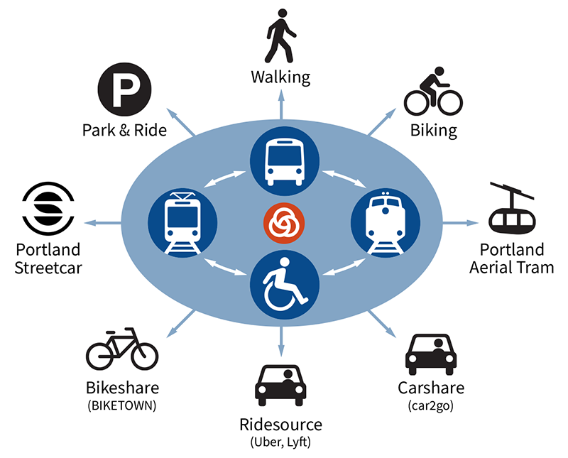
TriMet proposed to extend our existing multimodal trip planner to include private mobility service providers. Thirty-eight private and public partners collaborated on the two-year project, which was completed on-time and within budget in January 2019.
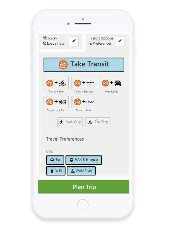
As a result, TriMet was the first US transit agency to release a multimodal trip planner that incorporatesd shared-use mobility service providers, including BIKETOWN, car2go, Lyft (pilot only participation), Uber and Zipcar. This was a fundamental step towards providing our customers with convenient, personalized door-to-door travel options.
The new trip planner was designed to be easily replicated by transit agencies in other cities. Because it uses open source technology and open data, including OpenStreetMap, other transit agencies can quickly adjust the trip planner for their system. TriMet can then benefit from improvements other agencies make and incorporate them into our trip planner.
On February 27, 2019, the TriMet Board of Directors was briefed on the project. The recording is available here and the slides are available here.
 Since then, the version of the OpenTripPlanner created during the MOD grant has been deployed by multiple other transit agencies, including:
- SEPTA
- AC Transit
- Houston Metro
- Florida Department of Transportation District 5
- ATL (Atlanta-Region Transit Link Authority)
- New York State DOT 511 traveler information system
- Community Transit (Coming Summer 2022)
Project Overview
TriMet’s FTA MOD Sandbox Project included the following deliverables:
- A complete open platform for the integration of transit and shared-use mobility options into the OpenTripPlanner, an open source multimodal trip planner
- A mobile-friendly web interface with integrated real-time information
- An improved and sophisticated Pelias Geocoder, now part of the Linux Foundation
- OpenStreetMap data improvements, including sidewalks, speed limits, and business names and locations
- A final project report
The goal was to make transit planning information easily accessible in one application, so that customers can make more informed decisions. The new trip planner is accessible on both desktop and mobile devices, and includes modern, simplified customer-focused improvements. Additional features will be added as we continue to engage with customers.
We are just beginning to understand the advantages that multimodal trips provide. For example, for some trips, total transit trip time can be reduced when combined with Lyft or Uber, and can be cheaper than taking Lyft or Uber door-to-door.
Main Features:
- Adjustments to transit trips are made based on real-time information.
- The Book Ride button makes it easy to confirm, book and pay for Uber trips and we plan to provide further integration in the future.
- In addition to providing bike and walk only trips, BIKETOWN trips can be planned both on their own and combined with transit. Information regarding available bikes and docks are available in real-time. Bike trips can also be optimized for speed, bike-friendly or flattest trip.
- Additional modes included car2go and Zipcar when the 2-year project was completed. E-scooters were added later when they arrived in our region.
- Mapping layers include detailed aerial imagery, Zipcar locations, and more.
- Improved sidewalk data supports more comfortable pedestrian routing.
- The address locator (geocoder) was also improved with more local destinations and better recognition of addresses. A fully functional and comprehensive open geocoder, built off the existing Mapzen Pelias geocoder, was implemented. This non-proprietary and non-restrictive option for address locating substantially lowers the barrier to entry for many transit systems to offer trip planning, and can achieve significant cost savings for transit agencies, government agencies, and the public.
The final result is a comprehensive trip planner and a robust geocoder that are powered by open data and can be replicated throughout the world.
Our strategy of leveraging existing open source software, data and standards, produced a product that can easily and cost-effectively be implemented by other transit agencies. TriMet initiated the development of this open source multimodal trip planner in 2009 as a cost-effective alternative to transit-only trip planners. OpenTripPlanner is now deployed worldwide, including the nations of of Finland, Norway and the Netherlands. Everyone benefits from our improvements, and we from theirs.
The MOD Sandbox project was divided into six main tasks: Project Management, Evaluations & Reports, Application Development, Geocoder Development, Data Improvements and an Integrated Payment Plan.
Partners
This project was a collaborative effort that consisted of private and public entities working together to find highly creative solutions to complex problems. TriMet would like to acknowledge everyone who contributed to the successful completion of the project, which lays the groundwork for future cooperative initiatives.
This project would not have been possible without the opportunity and support provided by the visionary team responsible for the MOD Sandbox Grant, including the FTA Office of Mobility Innovation, notably Vincent Valdez, Christina Gikakis, Gwo-wei Torng and Steven Mortensen. TriMet would like to offer a special note of appreciation to Murat Omay, TriMet’s FTA Project Manager, for his guidance, encouragement and support.
TriMet gratefully acknowledges the following outstanding contributors:
Key Project Partners
- IBI Group - Project Coordination
- Conveyal LLC - Application Development and Design Team
- Cleared for Takeoff and Mapzen - Pelias Geocoder Development Team
- Oregon Metro - Regional Address Improvements
- moovel North America - Integrated Payment White Paper
Project Partners
- AC Transit (Alameda-Contra Costa Transit District), City of Portland, CUTR, Fehr & Peers, LA Metro (Los Angeles County Metropolitan Transportation Authority), Motivate, Portland Streetcar, VTA (Santa Clara Valley Transit Authority), VTrans (Vermont Agency of Transportation)
Data Providers
- BIKETOWN, Lyft, car2go, Uber, Zipcar
Active Contributing Participants
- BART (Bay Area Rapid Transit Authority), Booz Allen Hamilton, Cambridge Systematics, Clevor Consulting Group, Connective DX, DKS Associates, Full Path Transit Technology, Interline Technologies, Lane Transit District, Oregon Department of Transportation, PlusQA, ReachNow, RTD (Regional Transportation District of Denver), Ride Connection, Samsung, Shared-Use Mobility Center, Transportation Sustainability Research Center, UC Berkeley, Trillium Transit
OpenTripPlanner
OpenTripPlanner (OTP) is an open source, multimodal trip planning system that is collaboratively developed by a team from across the world. Initially coordinated by OpenPlans and TriMet, the OTP Project was first funded through a Metro 2009–2011 Regional Travel Options Grant.
TriMet’s original text-based trip planner was a proprietary system, providing transit trip itineraries with limited walking instructions. However, it could not plan multimodal trips (e.g., biking to transit), and customers frequently requested this functionality. The ability to plan trips that combined transit, walking, and biking, and to bring as much information as possible into one central location would allow commuters to make informed decisions about their transportation choices while encouraging sustainable modes and decreasing the number of drive-alone vehicle trips. Commercial off-the-shelf solutions were cost prohibitive for TriMet and many US transit agencies, and open source, multimodal trip planners were relatively new to the market and lacked a strong user and developer base and a sustainable support model.
TriMet was interested in bringing stakeholders together to collaborate on an open source multimodal trip planning system that would not only meet TriMet’s increasing needs, but could potentially be a viable alternative for other agencies. TriMet partnered with OpenPlans, a non-profit organization that specialized in open source software and civic projects, and several other developers, on applying for a Metro Regional Travel Options (RTO) Grant in 2008 to begin work on an open source, multimodal trip planner, which came to be known as the OpenTripPlanner. OpenPlans was responsible for leading the technical development of the project, facilitating a strong development community around the code, and providing a sustainable business model around the software to ensure there were maintenance and support options for agencies. TriMet successfully launched the multimodal trip planner in 2011.
Pelias Geocoder
Pelias is a modular, open source geocoder built on top of Elasticsearch for fast and accurate location searches. Find out more about Pelias at https://pelias.io/.
Interesting features of Pelias include:
- Completely open source and MIT-licensed
- Became a Linux Foundation project in January 2019
- A powerful data import architecture: Pelias supports many open data projects out of the box, but also works great with private data
- Support for searching and displaying results in many languages
- Fast and accurate autocomplete for user‐facing geocoding
- Support for many result types: addresses, venues, cities, countries, and more
- Modular design, so you don't need to be an expert in everything to make changes
- Easy installation, with minimal external dependencies
Reports
MOD Sandbox Project Final Report
The Federal Transit Administration has published the final project report. Topics include:
- Project Overview
- OpenTripPlanner and Pelias Geocoder Enhancements
- Data Improvements
- Integrated Payment Plan
- Evaluation and Testing
- Key Lessons Learned
- Next Steps
- Appendices include:
- “Open Source Transit Software White Paper,” a white paper by the Center for Urban Transportation Research (CUTR)
- “Practical Design of a Mobility on Demand Payment Platform,” a white paper by moovel
- An external assessment of the Pelias Geocoder, by Fehr and Peers
MOD Sandbox Project Quarterly Reports
Contact
For more information, contact Bibiana McHugh, TriMet Manager of Mobility & Location-Based Services at mchughb@trimet.org.